


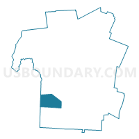
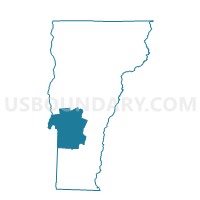
Wells Voting District, Rutland County, Vermont
About
Outline

Summary
| Unique Area Identifier | 680893 |
| Name | Wells Voting District |
| County | Rutland County |
| State | Vermont |
| Area (square miles) | 22.99 |
| Land Area (square miles) | 22.11 |
| Water Area (square miles) | 0.88 |
| % of Land Area | 96.18 |
| % of Water Area | 3.82 |
| Latitude of the Internal Point | 43.44298600 |
| Longtitude of the Internal Point | -73.19108580 |
Maps

Graphs
Select a template below for downloading or customizing gragh for Wells Voting District, Rutland County, Vermont


Neighbors
Neighoring Voting District (by Name) Neighboring Voting District on the Map
- Voting District 070001, Washington County, NY
- Voting District 070003-070005, Washington County, NY
- Danby Voting District, Rutland County, VT
- Middletown Springs Voting District, Rutland County, VT
- Pawlet Voting District, Rutland County, VT
- Poultney Voting District, Rutland County, VT
- Tinmouth Voting District, Rutland County, VT
Top 10 Neighboring County Subdivision (by Population) Neighboring County Subdivision on the Map
- Granville town, Washington County, NY (6,669)
- Poultney town, Rutland County, VT (3,432)
- Pawlet town, Rutland County, VT (1,477)
- Danby town, Rutland County, VT (1,311)
- Wells town, Rutland County, VT (1,150)
- Middletown Springs town, Rutland County, VT (745)
- Tinmouth town, Rutland County, VT (613)
Top 10 Neighboring Place (by Population) Neighboring Place on the Map
Top 10 Neighboring Elementary School District (by Population) Neighboring Elementary School District on the Map
- Mettawee Community Union School District 47, VT (2,191)
- Currier Memorial Union School District 23, VT (1,566)
- Wells School District, VT (1,150)
- Middletown Springs School District, VT (745)
- Tinmouth School District, VT (613)
Top 10 Neighboring Secondary School District (by Population) Neighboring Secondary School District on the Map
Top 10 Neighboring Unified School District (by Population) Neighboring Unified School District on the Map
Top 10 Neighboring State Legislative District Lower Chamber (by Population) Neighboring State Legislative District Lower Chamber on the Map
- Assembly District 112, NY (139,495)
- Bennington-Rutland-1 State House District, VT (4,130)
- Rutland-8 State House District, VT (3,988)
- Rutland-3 State House District, VT (3,748)
- Rutland-1-1 State House District, VT (3,524)
Top 10 Neighboring State Legislative District Upper Chamber (by Population) Neighboring State Legislative District Upper Chamber on the Map
Top 10 Neighboring 111th Congressional District (by Population) Neighboring 111th Congressional District on the Map
Top 10 Neighboring Census Tract (by Population) Neighboring Census Tract on the Map
- Census Tract 840, Washington County, NY (6,669)
- Census Tract 9638, Rutland County, VT (4,582)
- Census Tract 9635, Rutland County, VT (1,790)
- Census Tract 9642, Rutland County, VT (1,566)
- Census Tract 9643, Rutland County, VT (1,477)
Top 10 Neighboring 5-Digit ZIP Code Tabulation Area (by Population) Neighboring 5-Digit ZIP Code Tabulation Area on the Map
- 12832, NY (7,106)
- 05764, VT (3,452)
- 05774, VT (1,129)
- 05761, VT (1,000)
- 12837, NY (857)
- 05757, VT (832)
- 05775, VT (623)